By Jennifer Corcoran – Remote Sensing Program Consultant and Keb Guralski – Statewide Forest Inventory Coordinator, DNR Resource Assessment
Forest inventory plays a crucial role in good forest management. For example, in the last MFA Newsletter, readers learned that knowing your fire fuel load means having good forest inventory. Brian Huberty’s article explained how these datasets can provide critical information to help wildland firefighters and provides foundational information for land managers and planners working at the site-to-landscape scale. Minnesota’s legislature agrees with the importance of forest inventory data and has provided substantial funding to enhance forest inventory in Minnesota. This is part of the ~$4 million investment in private forest land management that Doug Tillma (strategic planning and policy section manager with the Minnesota Department of Natural Resources – MN DNR) recently summarized for MFA.
Traditionally, MN DNR has inventoried about 120,000 acres per year, out of approximately 3.7 million acres of state administered forest land. Conducting this forest inventory means visiting each forested ‘stand’ with boots on the ground. It takes nearly 20 years to visit every stand with these traditional methods. No comprehensive inventory exists for Minnesota’s private woodlands.
To address this information gap, the MN DNR Resource Assessment Program (RAP) is developing a lidar (light detection and ranging) based forest inventory using Plot Based Inventory (PBI) across Minnesota. A pilot project funded by the Environment and Natural Resources Trust Fund (ENRTF) tested this new methodology and provided Minnesota with a preview of the quality and kinds of forest inventory data that will soon be available statewide. Continued funding from the State of Minnesota and ENRTF, amongst other partners, will help to drastically reduce the turnaround time and overall cost of forest inventory, while dramatically increasing the amount and kinds of information provided.
Lidar is a technology that uses active pulses of light to estimate the distance from a sensor to an object of interest. The amount of time it takes for the signal to reach, and then reflect off an object and travel back to the sensor (at the speed of light) is used to calculate the location and elevation of the features scanned.
For example, a lidar camera in an airplane can scan across the landscape providing a detailed representation of the ground and everything above it. In a forest, the laser pulses hit treetops, travel through canopy gaps, sometimes hitting the ground or scattering. The reflected laser pulses return to the sensor, providing a cloud of points mapping the position and elevation of things on the Earth’s surface.
Lidar derived forest inventory models combine the lidar derived information with a network of forest inventory plots called Plot Based Inventory (PBI). Since lidar is flown “wall to wall,” forest inventory models can be made across “all lands” throughout the state. This information can be summarized for any area and used for all sorts of decision-making purposes – like forest stewardship!
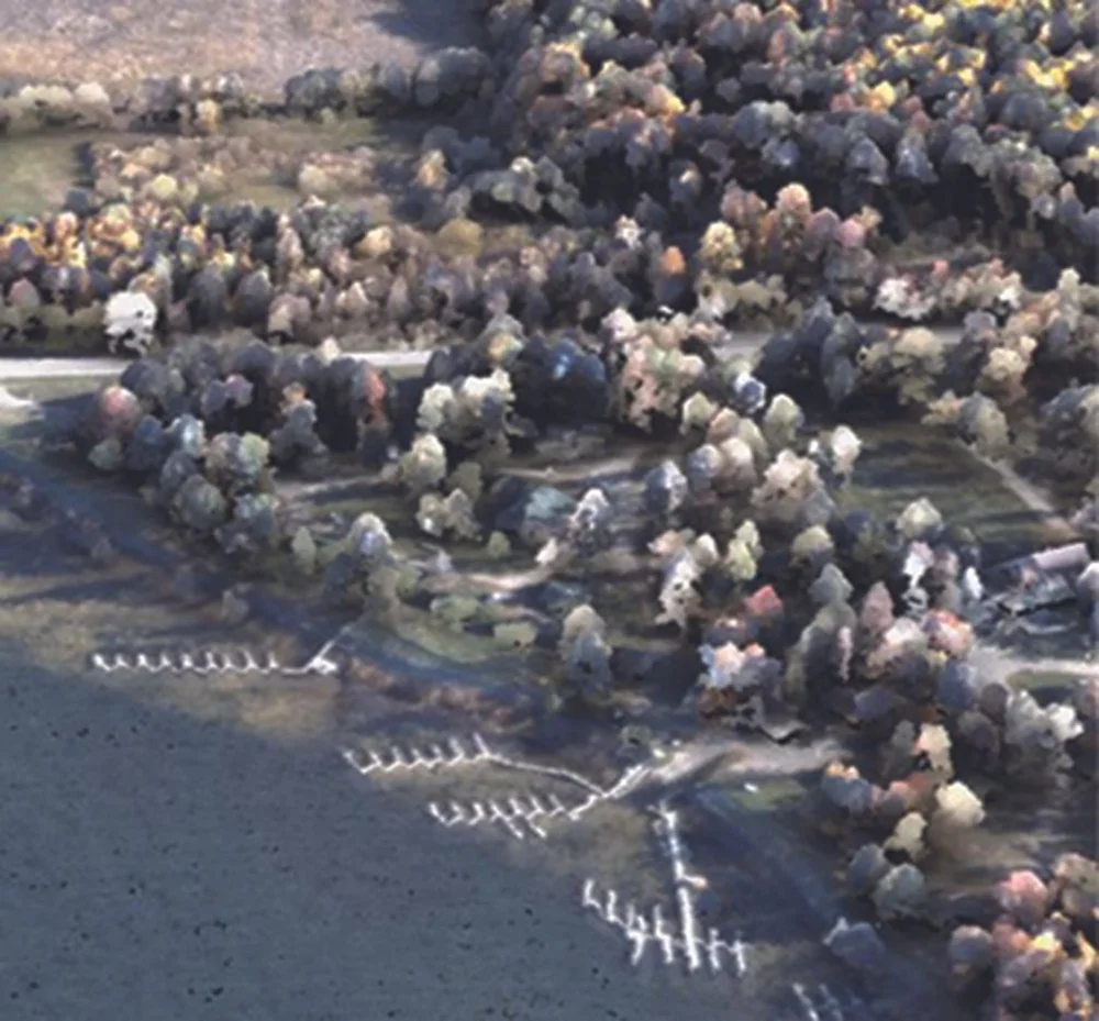
A photo taken around the same time as lidar point cloud provides incredible detail! The information shown in this example can be summarized in many different ways to help landowners and professionals manage the forest.
Now, to one of the most important messages of this article: More plots on private woodlands are needed to increase the precision and accuracy of these new forest inventory models and maps. The fieldwork needs to be representative of all forested conditions to produce the best models across entire landscapes. Until now, PBI has been collected primarily on public lands. Expanding PBI to private woodlands will provide valuable information to increase the accuracy of forest inventory models statewide.
By enrolling in the PBI program, select landowners will voluntarily agree to have forest inventory plot data collected by a professional forester on their land. Importantly, there are no other obligations.
Consider having a plot measured on your land and volunteer today! MFA members have already taken the first step toward land stewardship by their involvement and interest in forest management. Here’s another step you can take!
Please visit the RAP website (mndnr.gov/resource-assessment) to access the enrollment portal. You can request assistance enrolling or receive additional resources through entering your information in the portal. You can also access more information about PBI Data Collection, including field manuals, tutorial videos, news stories and more!
Questions? Email MFA at info@minnesotaforestry.org or MN DNR Resource Assessment at ForestInventory.dnr@state.mn.us.
How does it work?
-
Landowner volunteers to have a PBI plot collected on their property. Landowners can enroll or request assistance enrolling through the enrollment portal on the Resource Assessment Program (RAP) website (mndnr.gov/resource-assessment) or by contacting info@minnesotaforestry.org.
-
Landowners choosing to enroll, request assistance, or request additional information will be asked to volunteer their contact information (home address, phone, email). Enrollees will be asked basic details about their land, including location of their property or parcel ID(s), size, and forest cover types. This information will be shared with MFA and a local cooperating forestry professional to follow-up with you. Note: enrollment does not guarantee a plot will be collected on your property.
-
Landowners selected for a plot will be contacted initially and again prior to plot collection to confirm interest, parcel location as well as to determine timeline for plot collection.
-
A professional forester will collect the PBI data by visiting a one tenth acre circular forest plot to count and measure all the trees above 5 inches in diameter.
-
Collection of plot data is anticipated to begin in Fall of 2024 and continue into the Summer of 2025.
This post is an excerpt from the original article. We’re just sharing this great piece with our readers! All credit goes to the original author and website. Please click the link to read the full content on their website.
This content is aggregated for informational purposes only. We do not claim ownership and encourage readers to view the full article on the original publisher’s site via the provided link.